Monday, January 17, 2011

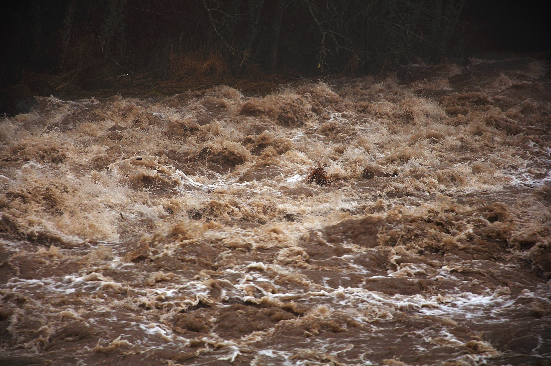
Flood On The Hood!


On Saturday, January 15, a warm moisture-laden Pineapple Express took direct aim at the Pacific Northwest. Freezing levels skyrocketed, moving high above the ski areas, and 5-6 inches of orographically (I love that word) enhanced rain fell on Mt Hood over the weekend. Timberline Lodge recorded the most, with a bit over 9" rain. Hood River itself received about 1.5" of rain during that time.

As a result, the flow and level of the Hood river started rising dramatically, and kept rising until it topped out Sunday afternoon at 12.9 feet on the Tucker Bridge gauge. Peak flow was estimated to be 13,500 cfs. That was just barely into the flood stage, but still way impressive. This was the highest flow on the Hood since Nov 2006. For a list of peak flows dating back to 1898, click here.

This was almost certainly the most photographed and videotaped flood on the Hood ever. I've assembled some links to videos and pictures below, and will add more as I find them. Let me know if I've missed any.

Gary Boggs (waveguru) won the honors of having the first video posted on YouTube (the video above), followed by this video, both taken near the old Copper Dam site.

Dan Kleinsmith posted this video and photo, also taken near the Copper Dam site.

OleFOgey took this video of river action at various locations in the upper valley.

The view at Tollbridge Road, posted by dherneisen.

Upstream from the railroad bridge, Temira's video.

Near the mouth of the Hood, Mike S. captured the river at the railroad bridge.

And the winner for the best overall video collage of the event, this from Hood River News/Adam Lapierre.


On the other side of the mountain, the Sandy river raged, isolating some homeowners and doing a considerable amount of damage. Professional quality video.

Friday, January 7, 2011

December 2010 Revisited

Compared to historical averages, December in Hood River was warmer, wetter, and less windy.

At my weather station, the average temperature of 36.2° was warmer than long term averages (35.7°), and also warmer than the more recent (2000-2009)
average of 35.6°.

The high heat index for the month was 51°, and the low wind chill was 20°.
Barometric pressure peaked at 30.40", with a low of 29.22".

December's precipitation (6.91") was above average (5.83"). The month started out dry, but turned quite wet from 12/8 to 12/14, as a moisture-laden atmospheric river took direct aim at the Pacific Northwest. 75% of the monthly precipitation fell in that time frame. That was followed by 3 days of snow, during which a total of 10 inches of snow fell. All in all, we had 11" of snow for the month, higher that the long term snow average of 8.7".

Given that this was a strong, well established La Nina winter, with the jet stream fire hose pointed firmly at us, things took an odd turn halfway though the month. The jet stream moved south big time, drenching California with record rains and snowfall. Our precipitation fell off dramatically for the rest of the month. It turns out this may have been due to a shorter term climate cycle called the Arctic Oscillation, which turned strongly negative, and pushed the jet stream further south.

I happened to be on vacation in southern California around Christmas, and had great fun watching the flash floods move through Palm Springs.

Meanwhile, back in Hood River, the 24 hour avg wind speed for December was 0.9 mph, compared to a historical average of 1.5 mph. The high wind gust at my station was 34 mph on Dec 29th.


There was 1 local weather record set in December. On 12/12, at the peak of the Pineapple Express, we received 1.61" of rain, which broke the old record of 1.55" (1946).

The tabular data below is from my home weather station.
To view its December 2010 monthly summary and graphs at Weather Underground, click here.

The "historical average" numbers for temperature and rainfall are from the Hood River MCAREC data. Historical wind average is from my station's 2000 to 2009 data. Note that average wind speeds include all 24 hours of the day and night, which is why they are way lower than daytime peak winds. In addition, the wind speed at this station is considerably lower than on the Columbia River.


HighLowAverageHistorical Average
Temperature (F) 51
22
36.2
35.7
Wind (mph)34

0.9
1.5
Rainfall (in)1.45

6.91 (total)
5.83


California... a nice place to have grown up, and to visit, but luckily, I didn't get stuck there again.

Monday, January 3, 2011

2010 Weather Summary

For some unknown reason, I did a yearly weather summary last January. For the same unknown reason, it only seems fitting that I should continue the tradition this January. Maybe some January I'll remember the reason, and hopefully it will be so trivial that I can ignore it from then on.

But, I can't ignore it now, so here goes. 2010 in a nutshell:

2010 in Hood River was warmer than long term averages, but cooler than recent (2001-2009) averages. Precipitation was above average, and wind speed was somewhat below average.

The average temperature for 2010 was 51.9 degrees, which oddly enough was the exact average temperature for the previous year, 2009. This was 1.3 degrees warmer than long term averages, but 0.4 degrees cooler than recent averages. I thought it was going to be a cooler average temperature than it was, given that this was "The Year Without Much Of A Summer". But, that's yearly averages for ya.

We received 34.41" of precipitation, which was 3.86" above average. A total of 20" of snow fell, well below the average of 36".

The 24 hour average wind speed for the year was 2.4 mph, which is lower than the 2001-2009 average of 2.9 mph. In fact, overall, this was the least windy year since 2001. Now, I know that wind sports enthusiasts, who remember the summer of 2010 as a Most Excellent One for wind, are probably saying "Dude, you're totally crazy". I won't dignify that remark with a response, other than to say "Oh yeah?? Hey, it takes one to know one!"

But, back to the yearly wind average, the higher wind speeds in the summer months were averaged down by the lower wind speeds the other months of the year.

Click here for all of my weather station's 2010 data on Weather Underground, with nice 12-month graphs and all 365 days of action packed weather-type data.


High Low Average Historical Average
Temperature (F) 100.7
14.0
51.9
50.6

Wind (mph) 38

2.4
2.9

Rainfall (in) 1.61

34.41
30.55

Barometric (in Hg) 30.66
29.04


Just another manic New Year... I was just in the middle of a dream...

Sunday, December 19, 2010

Once In A Lifetime

Actually, way less often than that.

That's how often we have a full moon, total lunar eclipse, and a winter solstice, all on the same date. According to SpaceWeather.com: "
there is only one previous instance, since the year 1 AD, of an eclipse matching the same calendar date as the solstice, and that was on Dec 21, 1638. Fortunately we won't have to wait 372 years for the next one...that will be on Dec. 21, 2094."


And two days from now, December 21st, 2010, it all comes together once again, for a celestial show that will probably be obscured by clouds here in Hood River. However, that doesn't stop this extremely rare event from happening in our lifetimes, even if the visual part is behind clouds. We'll just have to use our vivid imaginations, watch it live or recorded on the internet, or check out Shadow And Substance, which does an excellent job of animating these sorts of cool happenings in the sky.

But really, the best part of this event: It's the gift that keeps on giving. From Dec 22nd on, the daylight hours start to get longer and longer.

So, Merry Christmas to y'all, and to all, a shorter night!

(unless you live in the Southern Hemisphere, in which case, never mind about the shorter nights)


Florida?? Merry Christmas from Hawaii, courtesy of Jimmy Buffett


Wednesday, December 1, 2010

November 2010 Revisited

Compared to historical averages, November in Hood River was pretty much average in temperature, less wet, and less windy.

At my weather station, the average temperature of 41.5° was exactly the same as long term averages (41.5°), but cooler than more recent (2000-2009)
averages of 42.0°. We had warmer than average temperatures from 11/1 to 11/7, then a dip below normal, then a rise above normal until the 22rd, and then... an Arctic Blast. The first "below 32°" temperature (23°) was recorded at my house on 11/22, and the peppers and tomatoes haven't been the same since. That made for a very late first freeze at Hood River city elevation, as it's usually about a month earlier.

The high heat index for the month was 65°, and the low wind chill was 12°.
Barometric pressure peaked at 30.66", with a low of 29.49".

Even though the monthly precipitation (4.77") was below average (5.31"), it was interesting precipitation. The month started out with rain on the 1st, followed by more rain on the 5th thru 11th, followed by more rain on the 15th thru 19th, and then... 2" of snow on the 23rd as the arctic air settled in. Followed by 2" of snow on the 27th, and topped off with 5 inches of snow and sleet on the 30th. This made for a 9" snow month, higher that the long term average of 2.7".

All in all, an early start to the snow season, and especially welcome up on the ski slopes.

The 24 hour avg wind speed was 1.4 mph against a historical average of 1.6 mph. The high wind gust at my station was 30 mph on Nov 16th.


There were 3 local weather records set in November. On 11/2, the high temperature of 67° broke the old record of 65 (1965). On 11/14, a new "high low" record was set; 50° (previous record 46° in 1999). And if that wasn't enough, the following day set another "high low" record of 54° (previous record 48° in 1999).

The tabular data below is from my home weather station.
To view its November 2010 monthly summary and graphs at Weather Underground, click here.

The "historical average" numbers for temperature and rainfall are from the Hood River MCAREC data. Historical wind average is from my station's 2000 to 2009 data. Note that average wind speeds include all 24 hours of the day and night, which is why they are way lower than daytime peak winds. In addition, the wind speed at this station is considerably lower than on the Columbia River.


HighLowAverageHistorical Average
Temperature (F)681441.541.5
Wind (mph)30
1.41.6
Rainfall (in)0.98
4.77 (total)5.31

A barely related footnote: As we enter the winter months, there's a tendency (at least on my part) to sleep more. And, I'm apparently in good company. Lions, for example, are sleeping tonight. At least, I sure hope they are.


Or, if you prefer, the version by The Tokens, the best known version in the long history of this song. God bless and preserve Africa's beauty and wildlife! Or... maybe that's our job. Anyway, it's home; it's where we all started.